-
-


-
Wall Color
in
Uncheck to hide the white line Check to show the white line -
-
.


Frame
Room
Gallery
Historic Map - Map of the State of Missouri And Territory of Arkansas, 1826 - Vintage Wall Art
Historic Map - Map of the State of Missouri And Territory of Arkansas, 1826 - Vintage Wall Art
Note: Sold out or unavailable
Couldn't load pickup availability
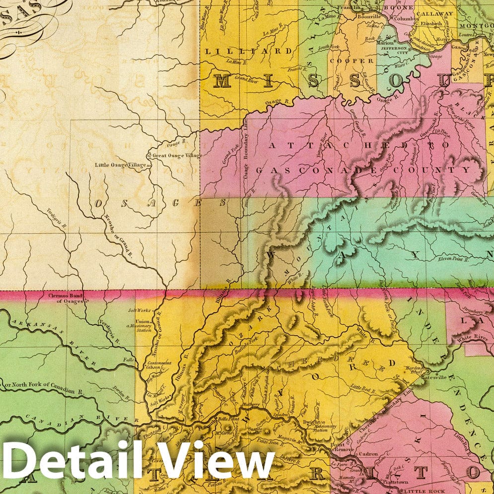
Map of the State of Missouri And Territory of Arkansas Compiled From The Latest Authorities. Drawn by D.H. Vance. Engraved by J.H. Young. Published by A. Finley Philadelphia 1826. | A New American Atlas, Designed Principally To Illustrate The Geography Of The United States Of North America; In Which Every Country In Each State And Territory Of The Union Is Accurately Delineated, As Far As At Present Known: The Whole Compiled From The Latest And Most Authentic Information. Philadelphia: Published By Anthony Finley, At The North-East Corner Of Chestnut And Fourth Streets. 1826. | This atlas was Finley's attempt to compete with Henry Tanner's American Atlas - the maps are grouped in much the same arrangement as Tanner used and the cartography and engraving are equal to Tanner, although the scale and map size are smaller. There are only two issues that we have seen, both dated 1826 on the title page, but with different dates on the maps. In the first issue (this copy) the maps are dated 1824-26; in the second issue the maps are dated 1826-27. Finley continued to publish the maps as pocket maps until 1831 when he sold his map and atlas copyrights to Mitchell, who reissued this American Atlas only once, in 1831 (see our #3884) but continued to issue the pocket maps, with updates, until about 1850. Bound in half leather marbled paper covered boards with red leather label stamped with "Finley's American Atlas" in gilt. Full color.
We print high quality reproductions of historical maps, photographs, prints, etc. Because of their historical nature, some of these images may show signs of wear and tear - small rips, stains, creases, etc. We believe that in many cases this contributes to the historical character of the item.
- MUSEUM QUALITY INKS AND PAPER: Printed on thick 192gsm heavyweight matte paper with archival giclee inks, this historic fine art will decorate your wall for years to come.
- VINTAGE MAP REPRODUCTION: Add style to any room's decor with this beautiful print. Whether your interior design is modern or classic, a map is never out of fashion.
- ATTENTION TO DETAIL: We edit every antique map for image quality, color and vibrance, so it can look its best while retaining historical character. Makes a great gift!
- FRAME READY: Your unframed poster will arrive crease-free, rolled in a sturdy mailing tube. Many maps fit easy-to-find standard size frames 16x20, 16x24, 18x24, 24x30, 24x36, saving on custom framing.
- Watermarks will not appear in the printed picture. Some blemishes, tears, or stamps may be removed from the final print.
Why choose Historic Pictoric
Every artwork we offer is carefully edited by our small but dedicated team of image professionals, ensuring each detail is perfect. We print every order to demand right here in the USA, treating every piece with the same care and attention we would give our own work. From editing to printing to packaging, we take pride in delivering artwork that meets our high standards—and we love knowing it’s heading to a home where it will be appreciated.
- Choosing a selection results in a full page refresh.
- Opens in a new window.