-
-


-
Wall Color
in
Uncheck to hide the white line Check to show the white line -
-
.


Frame
Room
Gallery
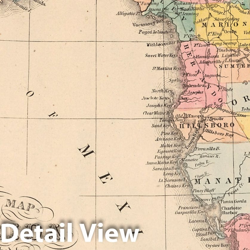
Historic Map : A New Map of the State of Florida : Published by Charles Desilver, 1859 - Vintage Wall Art
Historic Map : A New Map of the State of Florida : Published by Charles Desilver, 1859 - Vintage Wall Art
Note: Sold out or unavailable
Couldn't load pickup availability
A New Map of the State of Florida. Published By Charles Desilver, No. 714 Chestnut Street, Philadelphia. 21. Entered ... 1859, by Charles Desilver ... Pennsylvania. (to accompany) A New Universal Atlas Containing Maps of the various Empires, Kingdoms, States and Republics Of The World. | A New Universal Atlas Containing Maps of the various Empires, Kingdoms, States and Republics Of The World. With a special map of each of the United States, Plans of Cities &c. Comprehended in eighty one sheets and forming a series of One Hundred And Forty Five Maps, Plans And Sections ... Philadelphia, Charles Desilver, 714 Chesnut Street. 1859. Entered ... 1859, by Charles Desilver ... Pennsylvania. (title page by) J. Knight Sc. | This 1859 edition was published by Charles Desilver, copyright dates have been updated to 1859 or 1860, and was most likely issued in late 1859 or early 1860, as opposed to the previous 1859 edition that was published by Cushing & Bailey of 362 Market Street in Baltimore, with almost all copyrights dated 1856 (see: #4557.000). The maps bear the copyright and imprint of Charles Desilver 714 Chesnut Street. Changes from the 1859 edition includes a new map of Pennsylvania, two double page maps - map of Kansas by W.H. Holmes, and map of Mexico, with no pagination, as well as a double page map of Northern Italy which replaces map of Sardinia (Pl. 63), also various updates to individual maps. Maps in full color. Title page includes the vignette of the "First Landing of Columbus in the New World". Atlas includes 78 plates, some double page. Bound in half red leather brown paper covered boards.
- MUSEUM QUALITY INKS AND PAPER: Printed on thick 192gsm heavyweight matte paper with archival giclee inks, this historic fine art will decorate your wall for years to come.
- VINTAGE MAP REPRODUCTION: Add style to any room's decor with this beautiful print. Whether your interior design is modern or classic, a map is never out of fashion.
- ATTENTION TO DETAIL: We edit every antique map for image quality, color and vibrance, so it can look its best while retaining historical character. Makes a great gift!
- FRAME READY: Your unframed poster will arrive crease-free, rolled in a sturdy mailing tube. Many maps fit easy-to-find standard size frames 16x20, 16x24, 18x24, 24x30, 24x36, saving on custom framing.
- Watermarks will not appear in the printed picture. Some blemishes, tears, or stamps may be removed from the final print.
Why choose Historic Pictoric
Every artwork we offer is carefully edited by our small but dedicated team of image professionals, ensuring each detail is perfect. We print every order to demand right here in the USA, treating every piece with the same care and attention we would give our own work. From editing to printing to packaging, we take pride in delivering artwork that meets our high standards—and we love knowing it’s heading to a home where it will be appreciated.