-
-


-
Wall Color
in
Uncheck to hide the white line Check to show the white line -
-
.


Frame
Room
Gallery
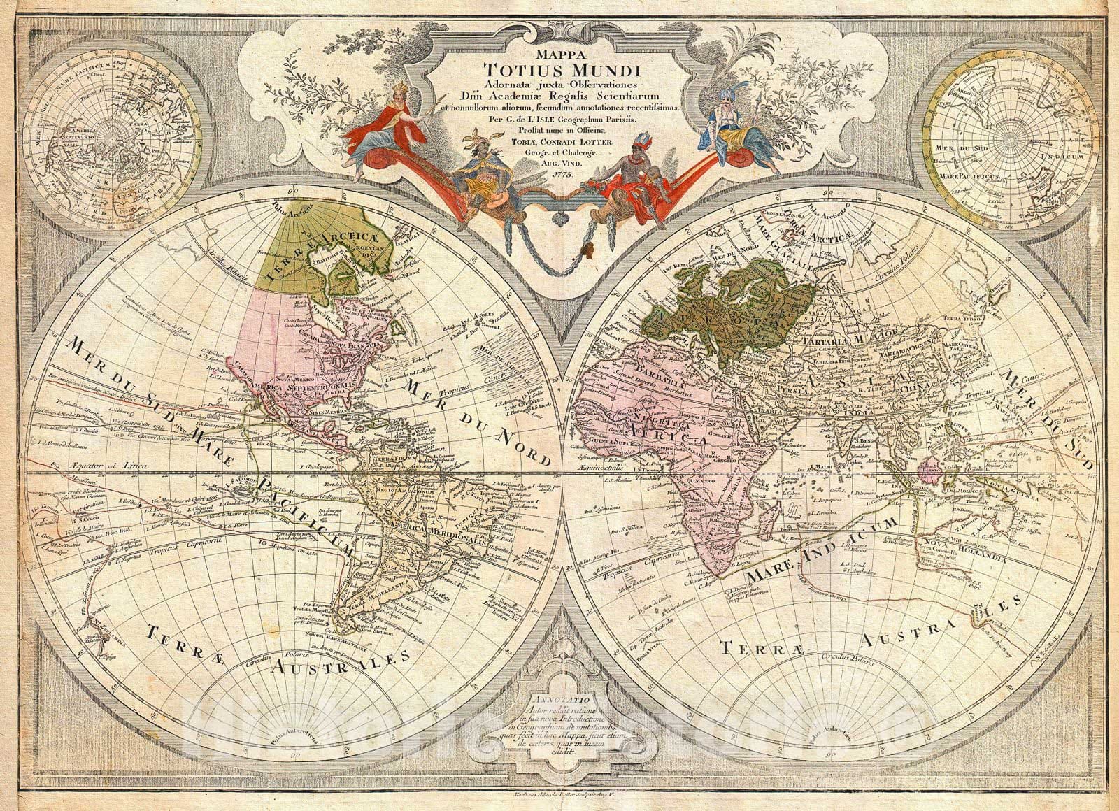
Historic Map : Lotter Map of The World on a Hemisphere Projection, 1775, Vintage Wall Art
Historic Map : Lotter Map of The World on a Hemisphere Projection, 1775, Vintage Wall Art
Note: Sold out or unavailable
Couldn't load pickup availability
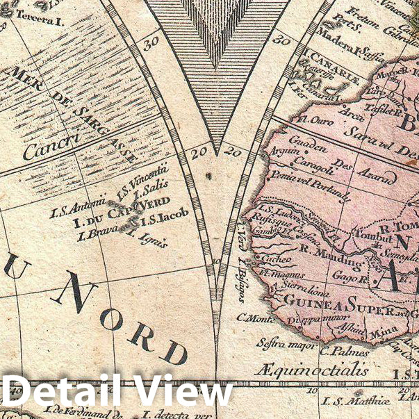
This is a stunning double hemisphere map of the world prepared by Guillaume de L'Isle and published by Tobias Conrad Lotter in 1775. The map is based upon the remarkable work of Guillaume de L'Isle. Depicts the entire world on a hemisphere projection with two smaller hemispheres describing the Polar Regions. In accordance with de L'Isle's rather high minded perspective on speculative cartography this map shows considerable restraint with regard to unknown and unexplored regions - particularly the northwestern parts of America, the northeastern parts of Asia, and the Australian continent. Unexplored areas are largely left blank. A few interesting anomalies did, however, work their way into this map. The most interesting of these is the depiction of "Frislandia" between Iceland and Greenland. Frislandia, not to be confused with Frisland, on the European mainland, is a "Ghost Island" that supposed appeared and disappeared on the horizon. Most maps issued by 1750 or so abandoned this notion, but as the legend and indeed this map attest, the island does have a habit of reappearing! On the opposite side of the world Japan is shown as a peninsula attached to the Asian Mainland of Yedso. Further east the mythical land of Terre de la Compagnie is also noted. To the south, Van Diemen's Land or Tasmania make a cursory appearance as does Antarctica, labeled "Cap. Terrae Australes". Australia is shows attached to New Guinea. New Zealand is not present. Shows the Saragossa Sea. Includes route markings delineating the explorations of Chaumont, Magellan, Tasmani, Dampieri and Olivieri, among others. The top center is dominated by a large allegorical title cartouche in the baroque style with continents depicted as royalty.
Why choose Historic Pictoric
Every artwork we offer is carefully edited by our small but dedicated team of image professionals, ensuring each detail is perfect. We print every order to demand right here in the USA, treating every piece with the same care and attention we would give our own work. From editing to printing to packaging, we take pride in delivering artwork that meets our high standards—and we love knowing it’s heading to a home where it will be appreciated.
- MUSEUM QUALITY INKS AND PAPER: Printed on thick 192gsm heavyweight matte paper with archival giclee inks, this historic fine art will decorate your wall for years to come.
- VINTAGE MAP REPRODUCTION: Add style to any room's decor with this beautiful print. Whether your interior design is modern or classic, a map is never out of fashion.
- ATTENTION TO DETAIL: We edit every antique map for image quality, color and vibrance, so it can look its best while retaining historical character. Makes a great gift!
- FRAME READY: Your unframed poster will arrive crease-free, rolled in a sturdy mailing tube. Many maps fit easy-to-find standard size frames 16x20, 16x24, 18x24, 24x30, 24x36, saving on custom framing.
- Watermarks will not appear in the printed picture. Some blemishes, tears, or stamps may be removed from the final print.
What our customers are saying
★★★★★I purchased an historic map, 16x24 inch. It is beautifully printed on heavy stock. The lettering, colors, and details of the map are crisp and easy to read. I am highly satisfied and would certainly purchase from Historic Pictoric again!
Kent A.
★★★★★The deliverable was even better than the picture on the website. Was able to use it as a great show and tell this past Memorial Day (and two of the folks are my retired geology professors)!
Edward D.
★★★★★Ordered the Pan American Midway print to fit a lovely thrift-store gilded frame. I love showing off Buffalo's rich history and this is a pretty entertaining photo from 1901. Prompt shipping. Sturdy packaging.
Cindy O.
★★★★★I received my print within days of ordering, and it arrived well packed in a mailing tube. The print is high quality and exactly as advertised. I will use Historic Pictoric again in the future!
Cheryl H.
★★★★★Excellent product. Great fidelity in reproduction of the original. Fine/minute details were sharp, colors were vibrant, and thickness, texture and overall feel and quality of the paper were excellent. Very satisfied with my purchase.
Konrad B.
★★★★★I have purchased six maps from Historic Pictoric. I find the quality to be excellent. Their customers service is also excellent. Outstanding! I called to exchange a few for different sizes and I could not have asked for a better experience.
Aaron C.
★★★★★The original map I ordered lacked some of the detail that I had hoped for, but they responded with several more map possibilities to choose from. Excellent service- a far step beyond what anyone expects from online purchases.
Dan M.
★★★★★I am a owner of 5 maps from Historic Pictoric. From Okinawa, 1945, Europe 1940-1945 battle maps. Now they’re helping me with the battle of Gettysburg. These maps are so much superior to the map on a page in a book. I have framed two of them.
Steven K.
★★★★★Great heavy paper quality and clarity of my nautical map. Will be a great addition to our home close to the beach!
Jennifer A