-
-


-
Wall Color
in
Uncheck to hide the white line Check to show the white line -
-
.


Frame
Room
Gallery
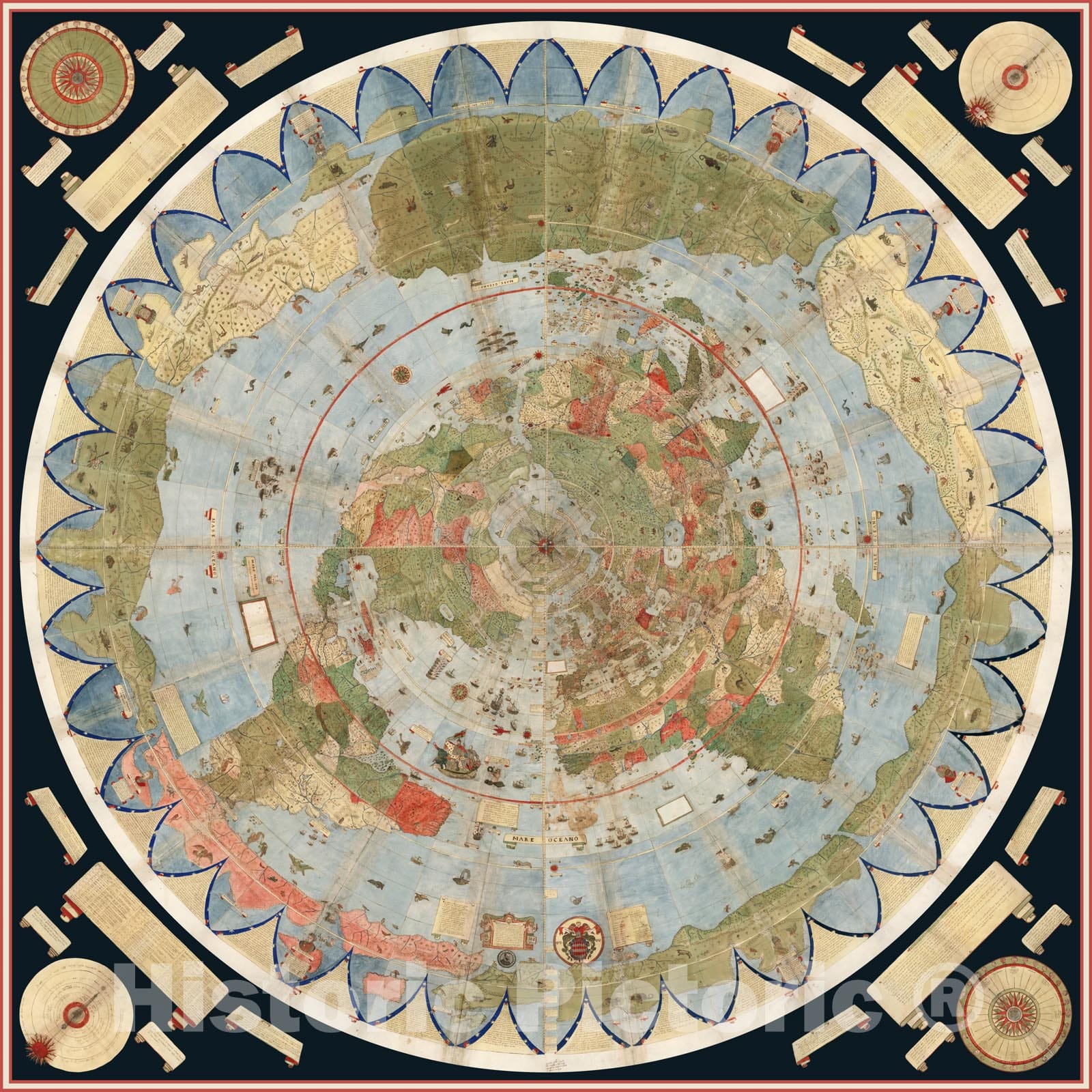
Historical Map, 1794 A map of The World on a globular Projection : exhibiting Particularly The Nautical researches of Captain James Cook, F.R.S, Vintage Wall Art
Historical Map, 1794 A map of The World on a globular Projection : exhibiting Particularly The Nautical researches of Captain James Cook, F.R.S, Vintage Wall Art
Note: Sold out or unavailable
Couldn't load pickup availability
Arrowsmith, a prominent English map maker and publisher, had a reputation for producing accurate and updated maps. His world map published in 1794 specifically delineated the voyages of Capt. James Cook during the 1770s and according to the title, purported to include "all the recent discoveries to the present time." Reflecting the accumulated knowledge gained from 18th-century voyages and explorations, the map provided a fairly good outline of all the continents, except for the Arctic coastline of North America. Unlike many of his 17th-century predecessors, Arrowsmith did not provide fictional information for unexplored areas or fill blank spaces with monsters or fanciful animals. Consequently, no continental land mass was indicated within the southern polar region and California was no longer shown as an island. In addition, the interior portions of western North America, Africa, and Australia were still relatively void of detail, setting the stage for further exploration during the 19th century. In designing this map, Arrowsmith used the double hemisphere projection, which he labeled a globular projection, a term that is still used today to designate this type of projection. In contrast to his 17th- and 18th-century predecessors, he left the areas outside the spheres entirely blank except for minimal embellishments of the title cartouche at the top center. This cartouche included exquisite calligraphy and a globe next to the portrait of Cook. In addition, the dedication at the bottom center was placed below a portrait of Alexander Dalrymple, who was just appointed director of the newly-founded British Hydrographical Office and to whom the map was dedicated.
- MUSEUM QUALITY INKS AND PAPER: Printed on thick 192gsm heavyweight matte paper with archival giclee inks, this historic fine art will decorate your wall for years to come.
- VINTAGE MAP REPRODUCTION: Add style to any room's decor with this beautiful print. Whether your interior design is modern or classic, a map is never out of fashion.
- ATTENTION TO DETAIL: We edit every antique map for image quality, color and vibrance, so it can look its best while retaining historical character. Makes a great gift!
- FRAME READY: Your unframed poster will arrive crease-free, rolled in a sturdy mailing tube. Many maps fit easy-to-find standard size frames 16x20, 16x24, 18x24, 24x30, 24x36, saving on custom framing.
- Watermarks will not appear in the printed picture. Some blemishes, tears, or stamps may be removed from the final print.
What our customers are saying
★★★★★I purchased an historic map, 16x24 inch. It is beautifully printed on heavy stock. The lettering, colors, and details of the map are crisp and easy to read. I am highly satisfied and would certainly purchase from Historic Pictoric again!
Kent A.
★★★★★Ordered the Pan American Midway print to fit a lovely thrift-store gilded frame. I love showing off Buffalo's rich history and this is a pretty entertaining photo from 1901. Prompt shipping. Sturdy packaging.
Cindy O.
★★★★★I received my print within days of ordering, and it arrived well packed in a mailing tube. The print is high quality and exactly as advertised. I will use Historic Pictoric again in the future!
Cheryl H.
★★★★★Excellent product. Great fidelity in reproduction of the original. Fine/minute details were sharp, colors were vibrant, and thickness, texture and overall feel and quality of the paper were excellent. Very satisfied with my purchase.
Konrad B.
★★★★★I have purchased six maps from Historic Pictoric. I find the quality to be excellent. Their customers service is also excellent. Outstanding! I called to exchange a few for different sizes and I could not have asked for a better experience.
Aaron C.
★★★★★The original map I ordered lacked some of the detail that I had hoped for, but they responded with several more map possibilities to choose from. Excellent service- a far step beyond what anyone expects from online purchases.
Dan M.
★★★★★I am a owner of 5 maps from Historic Pictoric. From Okinawa, 1945, Europe 1940-1945 battle maps. Now they’re helping me with the battle of Gettysburg. These maps are so much superior to the map on a page in a book. I have framed two of them.
Steven Ko
★★★★★Great heavy paper quality and clarity of my nautical map. Will be a great addition to our home close to the beach!
Jennifer A