Skip to content
icon-X
Close menu
Maps
World Maps
World War 2 Maps
Pictorial Maps
USGS TopoGraphic Maps
Art Prints
Blueprints
Fine Art Museum Collections
Claude Monet
Photographs
Modern Photos
Posters
Collections
Kid's Room
Autos, Trains & Rails
Monet and Manet
Brewery, Beer, Liquor & more
Holiday Ready to Gift Products
Log in
Follow Us
instagram
Instagram
Facebook
twitter
Twitter
Maps
World Maps
World War 2 Maps
Pictorial Maps
USGS TopoGraphic Maps
Art Prints
Blueprints
Fine Art Museum Collections
Claude Monet
Photographs
Modern Photos
Posters
Collections
Kid's Room
Autos, Trains & Rails
Monet and Manet
Brewery, Beer, Liquor & more
Holiday Ready to Gift Products
account
Log in
icon-search
Search
icon-hamburger
Site navigation
icon-bag-minimal
Cart
Search
Search
Free economy shipping for unframed orders of $75 or more!
Home
/
Historic Maps
Filter
icon-X
Close menu
Historic Maps
icon-filter
Filter
Historic Map : Summer Resorts of the Coast, Lake and Mountain Regions along the Boston and Maine Railroad and Connections, Vintage Wall Art
From:
$29.99
Historic Map : Africa, 1910 , Vintage Wall Art
From:
$49.99
Historic Map : Map of the United States-title in Ottoman Turkish, 1803 , Vintage Wall Art
From:
$49.99
Historic Map : Plan of Cape Arundel. A Section of the Lands of The Boston and Kennebunkport Sea Shore Co. at Kennebunkport Maine, February 15, 1873. James Cruickshan, 1873 , Vintage Wall Art
From:
$49.99
Historic Map : Trolley Wayfinder Birds Eye View of Trolley Routes in New England. Published by New England Street Railway Club. Boston, Mass 12 Pearl St., c. 1905 , Vintage Wall Art
From:
$49.99
Historic Map : Topography : New Hampshire-Maine Portsmouth Quadrangle, 1920 , Vintage Wall Art
From:
$49.99
Historic Map : Soil Map Oregon Yamhill County Sheet, 1917 , Vintage Wall Art
From:
$39.99
Historic Map : Schoonhoven, Vintage Wall Art
From:
$49.99
Historic Map : Sarasota C of C official map Sarasota Bank and Trust Company, 1972 , Vintage Wall Art
From:
$49.99
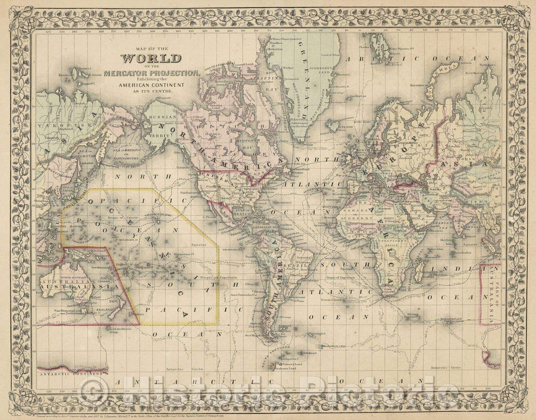
Historic Map : Map of the World on the Mercator Projection exhibiting the American Continent as its Centre., 1867 , Vintage Wall Art
From:
$49.99
Historic Map : Independent Tartary, 1851 , Vintage Wall Art
From:
$49.99
Historic Nautical Map - Approaches And Defences Of Knoxville, Tenn, TN, 1864 NOAA Civil War - Vintage Wall Art
From:
$49.99
Historic Nautical Map - Ilwaco, OR, WA, 1980 NOAA Topographic Bathymetric Historic Nautical Map - Vintage Wall Art
From:
$49.99
Historic Nautical Map - Gulf Of The Farallones, CA, 2000 NOAA Chart - Vintage Wall Art
From:
$49.99
Historic Nautical Map - Glacier Bay, AK, 2001 NOAA Chart - Vintage Wall Art
From:
$49.99
Historic Nautical Map - Cape Resurrection To Two Arm Bay, AK, 1982 NOAA Chart - Vintage Wall Art
From:
$49.99
Historic Nautical Map - Les Cheneaux Islands, 1979 NOAA Chart - Michigan (MI) - Vintage Wall Art
From:
$49.99
Historic Nautical Map - Lake St Clair, 1995 NOAA Chart - Michigan (MI) - Vintage Wall Art
From:
$34.99
Historic Nautical Map - Oneida Lake Lock 22 To Lock 23, 1997 NOAA Chart - New York (NY) - Vintage Wall Art
From:
$29.99
icon-chevron-left
Previous
1
…
26
27
28
29
30
…
1316
icon-chevron
Next
icon-X
"Close (esc)"
icon-chevron-left
icon-X
icon-chevron
icon-X
Historic Maps