-
-


-
Wall Color
in
Uncheck to hide the white line Check to show the white line -
-
.


Frame
Room
Gallery
Historic Map : Germany, Central EuropeNo. 32. Deutschland. 1846 , Vintage Wall Art
Historic Map : Germany, Central EuropeNo. 32. Deutschland. 1846 , Vintage Wall Art
Note: Sold out or unavailable
Couldn't load pickup availability
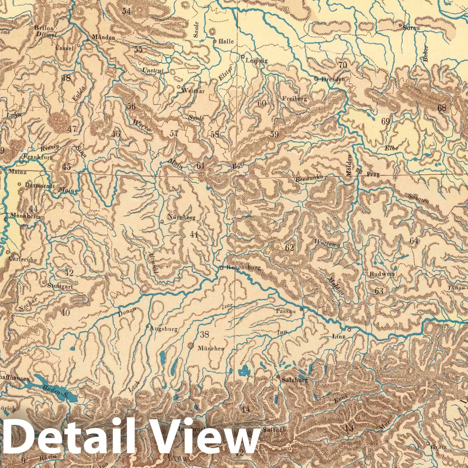
No. 32. Deutschland. | Handatlas der Allgemeinen Erdkunde, Laender- und Staatenkunde, In 80 Karten. Herausgegeben von L. Ewald ... Nebst einem Handbuch der allgemeinen Erdkunde. Laender- und Staatenkunde von Dr. E. Eder. Darmstadt, 1860. Verlag von Jonghaus & Venator's Kartogr[aphisch].-artist[ischen]. Anstalt. | Looseleaf color atlas with accompanying text sheets, all in unbound original publisher's parts/sections. Relief depicted with hachures. Atlas was conceived of and initiated by Georg Leonhart Bauerkeller beginning in 1844 by subscription. From at least 1845, Ludwig Ewald was a primary author and was responsible for drafting the maps. Considered by authorities to be one of the most beautiful atlases of the 19th century, it is particularly noteworthy for its quality registration, sharp images, use of brown for relief and solid blue for water, multi-color lithography, and it's scope of content. Particularly noteworthy presentations being: map, diagrams and illustrations of glaciers in the Alps (No.14. Die Gletscher der Alpen - List No 12189.036); an elevation diagram of major mountains and sea depths (No.39. Hoehen und Tiefen - List No 12189.061); map of Switzerland with relief depicted with hachures and giving a shaded relief 3-D effect (No. 54. Die Schweiz - List No 12189.076). Most of the text planned to accompany the maps was never completed. The atlas was largely ignored by contemporary and subsequent scholars despite its high quality. This is Espenhorst version 19.1.0-19.1.1.3. It consists of the initial set of 80 maps plus two sets of supplemental maps totaling 12 sheets - mostly revisions of previous editions. This scanned set has most of the section title pages at the end because the 80 sheets were not originally issued in the table of contents order that we present. Bauerkeller was also known for his three dimensional maps of cities, see our copies of London, Paris, Hamburg, and others.
- MUSEUM QUALITY INKS AND PAPER: Printed on thick 192gsm heavyweight matte paper with archival giclee inks, this historic fine art will decorate your wall for years to come.
- VINTAGE MAP REPRODUCTION: Add style to any room's decor with this beautiful print. Whether your interior design is modern or classic, a map is never out of fashion.
- ATTENTION TO DETAIL: We edit every antique map for image quality, color and vibrance, so it can look its best while retaining historical character. Makes a great gift!
- FRAME READY: Your unframed poster will arrive crease-free, rolled in a sturdy mailing tube. Many maps fit easy-to-find standard size frames 16x20, 16x24, 18x24, 24x30, 24x36, saving on custom framing.
- Watermarks will not appear in the printed picture. Some blemishes, tears, or stamps may be removed from the final print.
What our customers are saying
★★★★★I purchased an historic map, 16x24 inch. It is beautifully printed on heavy stock. The lettering, colors, and details of the map are crisp and easy to read. I am highly satisfied and would certainly purchase from Historic Pictoric again!
Kent A.
★★★★★Ordered the Pan American Midway print to fit a lovely thrift-store gilded frame. I love showing off Buffalo's rich history and this is a pretty entertaining photo from 1901. Prompt shipping. Sturdy packaging.
Cindy O.
★★★★★I received my print within days of ordering, and it arrived well packed in a mailing tube. The print is high quality and exactly as advertised. I will use Historic Pictoric again in the future!
Cheryl H.
★★★★★Excellent product. Great fidelity in reproduction of the original. Fine/minute details were sharp, colors were vibrant, and thickness, texture and overall feel and quality of the paper were excellent. Very satisfied with my purchase.
Konrad B.
★★★★★I have purchased six maps from Historic Pictoric. I find the quality to be excellent. Their customers service is also excellent. Outstanding! I called to exchange a few for different sizes and I could not have asked for a better experience.
Aaron C.
★★★★★The original map I ordered lacked some of the detail that I had hoped for, but they responded with several more map possibilities to choose from. Excellent service- a far step beyond what anyone expects from online purchases.
Dan M.
★★★★★I am a owner of 5 maps from Historic Pictoric. From Okinawa, 1945, Europe 1940-1945 battle maps. Now they’re helping me with the battle of Gettysburg. These maps are so much superior to the map on a page in a book. I have framed two of them.
Steven Ko
★★★★★Great heavy paper quality and clarity of my nautical map. Will be a great addition to our home close to the beach!
Jennifer A